Geoscience Australia stories
DAS unveils new tool for real-time bushfire tracking
Last week
#
dr
#
cleantech
#
cloud services
DAS has launched a tool for near real-time bushfire monitoring, helping organisations quickly identify affected customers and properties during disasters.
Australian AI cube satellites to revolutionise bushfire detection
Wed, 5th Jun 2024
#
ai
#
swinburne university of technology
#
university of south australia
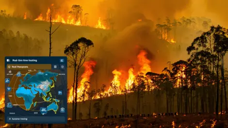
Australian scientists have developed AI-equipped cube satellites that can detect bushfires 500 times faster than traditional methods, promising quicker response and potentially saving lives and properties.
Inmarsat partners with Geoscience Australia for new research project
Tue, 21st Feb 2017
#
inmarsat
#
geoscience australia
#
partners
Inmarsat partners with Geoscience Australia for research project to enhance navigation accuracy using multiple satellite systems.